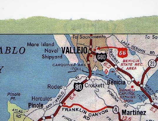
Black dots-water tanks http://geokov.com/education/topo-map-sy … egend.aspx
We are talking about the differences between the zodiacs map and the untouched sample.
Richard is pointing out that map makers use black dots to indicate water tanks. That could explain the black dots we see on the original and Zodiac maps. It doesn’t account for the dots that are on the Zodiac map and not on the original.
Richard is an excellent researcher and very knowledgeable of the case, it’s great to have his help on this. He has already pointed out one Zodiac type attack near one of the dots. If I am correct those murders have long been suspected of being a Zodiac crime. I’m not sure if they were ever solved.
I think that’s the way to take this now, see if we can find Zodiac style crimes near these dots. We have the one East of Sunol, also the one near the Zodiac writing west of Walnut Creek near Mt Diablo. We’ve established those red dots are on the original maps, I think they are a dead end.
Yep, i see the red dot now on both maps now.
What about the black dot near Stines murder turning red on z map, thoughts?
Well, like I say, it’s most likely due to simple color fading. It was exciting when I first noticed it on the Zodiac map since it is pretty much right where Stine was killed, but it’s also on the original map so it’s not something Zodiac added to his.
Disappointing I know, I thought the same thing about the red dot I noticed but it’s on the original also, same as the dot in Vallejo. I thought there was something to it only to be crestfallen when I saw it was on the original map as well.
Don’t lose heart thought. You’ve spotted some things we can look into. With the one east of Sunol being near a suspected Zodiac attack, there’s good reason to look into these. There are quite a few more of these dots around on the Zodiac map that aren’t on the original. We need to take them one at a time though.
I think Richard is like myself, he’s become intrigued by this and it’s worth looking into. More folks will come along and some of them are from the area and know it well along with crimes that happened that we might find a connection to. Be patient. If more of the heavy hitters join in we might find something.
Are you sure that copy (of the original) map is the right year? There was one in ’68 and ’70 and they are both close, but there are variations. I will pull mine and check. They usually label what that stuff (red dots) means.
Are you sure that copy (of the original) map is the right year? There was one in ’68 and ’70 and they are both close, but there are variations. I will pull mine and check. They usually label what that stuff (red dots) means.
I wondered that myself but it seems the numbers on the bottom are the same so I assumed it was the correct year. I don’t know however. Thanks Tahoe.
Are you sure that copy (of the original) map is the right year? There was one in ’68 and ’70 and they are both close, but there are variations. I will pull mine and check. They usually label what that stuff (red dots) means.
Hi tahoe, the red dots are to show distances between towns (not all) you will see a red mileage marker between them 10.3 eg
Apologise richard,
Its great having more capable people than I look into this, theres no other way to say it.
Theres one thing i should mention,
I found the North East Sunol dot rather whimsical via the 340 cipher.
It lead me first to seach for possible zodiac murders in the area of Pleasanton which was too north.
Whilst looking at the maps trying to find my bearings i stumbled on the discrepancy.
North East Sunol was a fitting match
Which makes me wonder if someone tampered with the digital images at some point.
Coincidence likely, the dots relevance unknown, spooky to myself yes it was.
I’ll elbaborate more when im more certain,
Im merely pointing to the relevance of that dot to myself.
This should be taken with a grain of salt.
Yes, dyslexia is probably my first undiagnosed language.
Richard Grinell said "Black dots-water tanks".
Perhaps this is generally true of other maps. On this specific Phillips 66 map,
however, I see no indication in the map symbols legend that a ‘black dot’
represents a ‘water tank’.
Tahoe27 said "Are you sure that copy (of the original) map is the right year?
There was one in ’68 and ’70".
Mike Butterfields’ webpage with the (non-zodiac) original map can be seen to
have the words "1969 Edition" in its map symbol legend area.;
http://zodiackillerfacts.com/The%20Mt.%20Diablo%20Map.htm
and can be seen to have the same ID "9-QQ-1219-S" on the bottom of its ‘SAN
FRANCISCO AND VICINITY’ portion (as CuriousCat intimated), as is seen on the
Zodiac map.
Note; The map back portion depicts North and South California with inserts
for the San Diego and Sacramento areas. Other ID numbers are visible, but
non-legible, on the bottom of the back portion of the map. These ID’s may be
the ID’s that are seen listed here;
http://www.oilcompanyroadmaps.com/uploa … dsheet.pdf
Interestingly, in the above spreadsheet, it can be seen that for the ‘Phillips
66′ GOU maps (n.b.; ‘GOU’ = ‘Gousha Company’, as can seen printed in original
maps previously mentioned map symbols legend area) that there is an apparent
sequential identification system being used with letters ‘NN’, ‘OO’, ‘PP’ and
‘QQ’ representing, respectively, 1966, 1967, 1968 and 1969. Therefore, although
the Zodiac map is incomplete and has only the torn off ‘SAN FRANCISCO AND
VICINITY’ portion, the presence of ‘QQ’ seen in the ID of that ‘SAN FRANCISCO
AND VICINITY’ portion acts to suggest that the Zodiac map was probably a 1969
edition map.
(Also, for reference;
http://www.oilcompanyroadmaps.com/Phillips-CA.php
)
CuriousCat said;
(Refering to the small Black Dot Small dot west of ‘Sunol’ and north of the
letter ‘l’ in ‘Alameda’) "There is a quarry near there too, have no idea if it
was there during that time though."
I agree that that dot could instead represent north of the quarry, in particular
trees running to northwards of the entrance to the Niles Canyon Quarry. That
quarry was certainy in existence in 1968, as shown by;
https://www.historicaerials.com/locatio … 83/1968/16
and the quarry roads look to have been in better condition back then than the
condition they are in now.
————-
In-cid-ent-ly…. thinking of that portion of the original Phillips 66 map we can
see, that says "California Points of Interest", with each area listed by a number…
http://zodiackillerfacts.com/images/Phillips%2066%20Map%20-%20FRONT%20large.jpg
It might be interesting to check a Phillips 66 map for Nevada, for 1969 or 1970, to
see if it also has an equivalent numbered Points of Interest. Possible relevance?
Thinking of -> "12" "pass" "LAKE TAHOE" "areas" <-
Cheers
CuriousCat said;
(Refering to the small Black Dot Small dot west of ‘Sunol’ and north of the
letter ‘l’ in ‘Alameda’) "There is a quarry near there too, have no idea if it
was there during that time though."I agree that that dot could instead represent north of the quarry, in particular
trees running to northwards of the entrance to the Niles Canyon Quarry. That
quarry was certainy in existence in 1968, as shown by;
https://www.historicaerials.com/locatio … 83/1968/16
and the quarry roads look to have been in better condition back then than the
condition they are in now.
————-
What we need though is to see if we can find any sort of missing person, murder, attempted attack etc. associated with these dots. Richard has show the one could possibly have some association with a Zodiac type double murder. I do remember a missing girl case, I believe she was a hitch hiker, who’s body was found in a quarry but I don’t believe it was in the Sunol area. Hopefully someone will remember what I am referring to and confirm it. I’ve been trying to find where I saw that but haven’t been able to find it.
Tammy Lynn Leppert
Case File 205UFCA Reconstruction of Victim Unidentified White Female Located on August 3, 1969 near a quarry on Highway 1, south of Lompoc, Santa Barbara County, California. The victim died from multiple stab wounds and a slit throat. Estimated date of death: July 29, 1969 Vital Statistics Estimated age: 16 – 25 years old Approximate Height and Weight: 5’2-5’4"; 120-130 lbs. Distinguishing Characteristics: Shoulder-length brown hair dyed a reddish blonde; blue eyes. She had pierced ears. She wore silver nailpolish. Dentals: Available. She had current dental work and "buck teeth". 19 fillings done within the year or two preceding her death. Based on her dental work, investigators surmised that she may have come from abroad. Clothing: She was wearing brown sandals with a gold colored buckle, a dark blue blouse and what appeared to be homemade white pants decorated with a blue floral print (daisies with red center), they were hip hugger bell bottons. The clothing appeared consistent with that worn by youth during this time period. A black bra and pink bikini panties. She wore thin, horseshoe shaped, gold earrings. Fingerprints: Available. (Poor quality) Pants Daisy Pattern and Victim’s Bucked Teeth Case History The victim lay a few feet down an embankment, her body dragged there across dust and scrub brush and dumped behind a cluster of rocks within sight of old Highway 1. Investigators believe she was killed there. She was stabbed numerous times. Investigators If you have any information concerning this case, please contact: Santa Barbara County Sheriff’s Department Cold Case Unit Detective Charles Cooley 805-681-4150 E-Mail NCIC Number: U-763720372 Please refer to this number when contacting any agency with information regarding this case. Source Information: Santa Barbara County Sheriff’s Department The Associated Press
https://www.tapatalk.com/groups/icaremi … -t708.html
https://en.wikipedia.org/wiki/Tammy_Lynn_Leppert

Thanks Richard. I do believe that is the one I remembered. Way down south though. Could be one of his " a hell of a lot more down there".
Here is a huge version of Zodiac’s "Mt. Diablo Map" :
http://www.zodiackiller.com/HugeMap.html
Mailed: June 26, 1970.
Postmarked: San Francisco, Calif.
Sent to: San Francisco Chronicle.
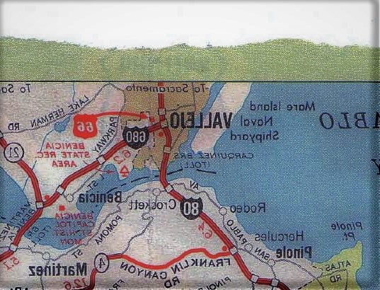
notice the writing at the top. has that been looked at before its pretty obvious
What writing? The "To Sacramento? That’s part of the map. If you’re talking about the faint stuff above it in the green portion, I believe that is the other side we’re seeing.
notice the writing at the top. has that been looked at before its pretty obvious
What writing? The "To Sacramento? That’s part of the map. If you’re talking about the faint stuff above it in the green portion, I believe that is the other side we’re seeing.
yes cc that faint bleed through any one discuss it before.. surely the police would know what it is or says. just curious
I assume it’s something printed on the other side showing through but we’d need someone with an original map to look at the other side and see if something corresponds. I think Tahoe said she has one, maybe she’ll check it out.


