Also by the court house, wasn’t Nancy Bennallack s court reporter. May be worth checking the court records for the two dates ?
I wonder if Belli was there on those dates ?
Wasn’t she in Sacramento?
Yes but her fiancé wasn’t.
<Still, the Richmond district – both Inner and Central – have dozens of blue collection boxes. Much more than the other mentioned neighborhoods.>
Good point. The Richmond District is probably the most densely populated of the neighborhoods in question, and there are two main shopping thoroughfares, Geary Boulevard and Clement Street.
Also by the court house, wasn’t Nancy Bennallack s court reporter. May be worth checking the court records for the two dates ?
I wonder if Belli was there on those dates ?
Wasn’t she in Sacramento?
Yes but her fiancé wasn’t.
Okay.
While we don’t have all of the mailing locations from all the letters, I think we can use some deductive reasoning to draw some conclusions. Fact check me:
We don’t have drop off locations for:
Bus Bomb
Belli
Little List
Dragon CardI think the Bus Bomb letter was also mailed from 4A (Balboa Terrace) because the Dripping Pen letter was mailed from that same location the day before.
I think the Little List letter was mailed from 6B Hayes Valley because the Johns letter was mailed two days prior from that same location and the next letter after came from there as well.
The Dragon card only has an H which narrows down the possibilities. I think it was mailed from 4H Miraloma because the My Name is Letter was mailed from nearby Balboa Terrace a week before and I can almost make out a "4" next to the B.
The Belli letter is the only postmarked letter that we have nothing to go on.
Thoughts?
If I was a betting man, I would guess it was done close to Belli’s address on Montgomery st. I say this due to the writing on the envelope, as previously discussed, matching the lettering font of address sign on Belli’s house.
Don’t know about street boxes but there were 6 post office locations within Belli’s district. There were 4 that were close to his office:
1. Mills Station – 220 Montgomery St. – 7 min walk 8 min drive
2. Station B – 555 Battery St. – 4 min walk 2 min drive
3. Chinatown Station – 753 Clay St. – 5 min walk 3 min drive
4. Ferry Annex – 125 The Embarcadero – 13 min walk 5 min drive
The closest post offices to his home would be:
1. Station 15 – 2300 Polk St – 29 min walk 8 min drive
2. Chinatown Station – 753 Clay St. – 14 min walk 6 min drive
3. Station B – 555 Battery St. – 13 min walk 6 min drive
4. Ferry Annex – 125 The Embarcadero – 20 min walk 9 min drive
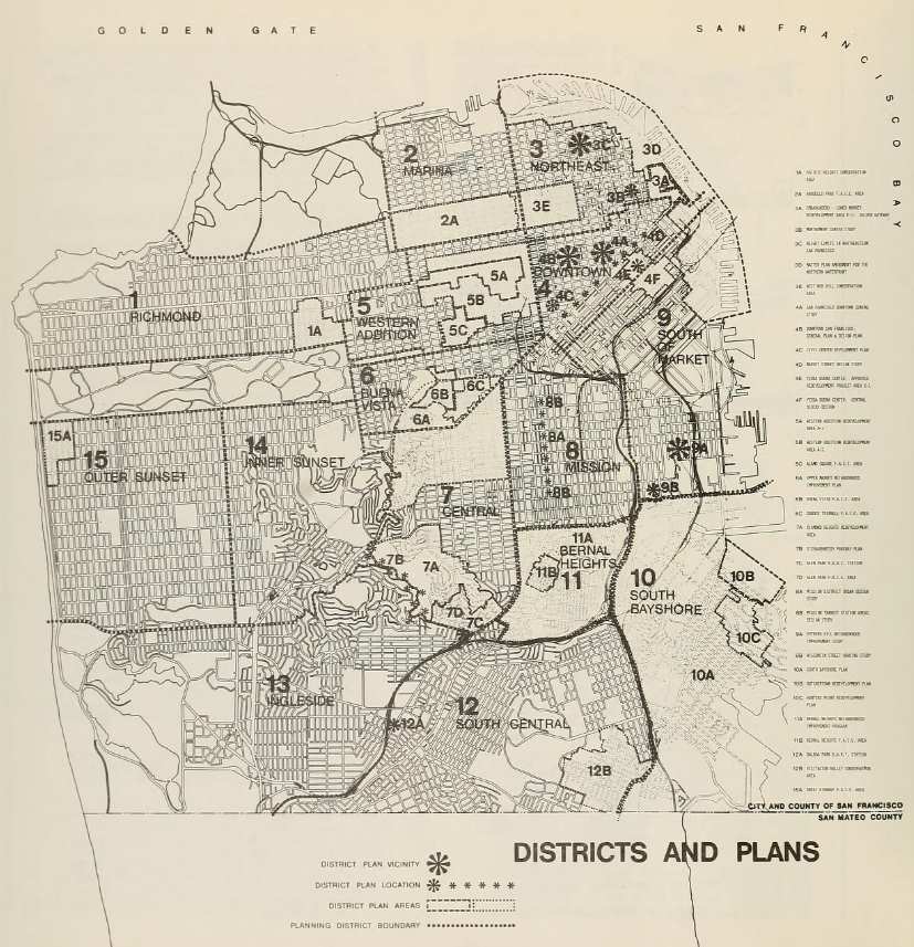
Just out of curiosity but are we sure that the district map used is the correct one? I understand that each district has these letters associated and visually they look appealing in relation to the envelopes. However, the city had there own district map, which unfortunately, didn’t include the letter designation. For example, district 8 on realtor map, would be district 3 on the city map. Just curious.
Soze

The credibility of the district maps is something that’s been in the back of my mind for a while. Still, I’m not sure how to verify that they are accurate and correspond to actual districts in San Fran.
“Murder will out, this my conclusion.”
– Geoffrey Chaucer
The only way to know for certain is to get a postal zone map for SF in 1970. Unfortunately as of yet I have been unable to locate one.
Agreed. I have exhausted every resource I know of to no avail.
“Murder will out, this my conclusion.”
– Geoffrey Chaucer
Well, I first started looking for a realtor map dated close to 1969 but couldn’t find one. All I found were relatively recent. Every time I did a search I kept noticing the city of San Francisco pop up with "district" in the short descriptions for the link. I finally clicked on the links and began comparing them to the realtor map. For each one the district sizes were fairly close to the realtor map with some exceptions in size. The biggest change was the district numbers like the example I gave above. District 1 stayed the same for both. I don’t know. Im just left wondering if we should be looking at the city instead. It would make sense given the post office is a government agency. However, how do you explain the letter designation?
Just wondering that’s all.
As far as the zones I will try and plug away at it and see what, if anything, I can come up with.
Soze
The place to begin would be the the US Postal Service. The federal government would have access to that information, not the city.
“Murder will out, this my conclusion.”
– Geoffrey Chaucer
The following link is in regards to the information we seek. A start only.
http://www.archives.gov/research/post-offices/locations-1837-1950.html
Soze
Is this what we need? It’s for 1960.
Soze
mailboxlocate.com

Nice work. Do you know which corner of Fell and Van Ness? That would help determine direction of travel.
Northwest corner of Fell and Van Ness. Right next to the offices of the San Francisco Unified School District.
ETA:
There are also schools located very near collection boxes in Miraloma and Balboa Terrace.
Miraloma Elementary School
175 Omar Way
San Francisco, CA 94127near
Collection Box
400 Molimo Drive
San Francisco, CA 94127
Walking Distance/Time: 0.2 miles/3 minutesand
Aptos Middle School
105 Aptos Avenue
San Francisco, CA 94127near
Collection Box
599 Upland Drive
San Francisco, CA 94127
Walking Distance/Time: 161 feet/1 minuteSo, you have potentially three drop spots located adjacent to schools or school offices.
Obviously brings the bus bomb and "shooting kiddies" threats to mind. Very interesting.
The only way to know for certain is to get a postal zone map for SF in 1970. Unfortunately as of yet I have been unable to locate one.
Here is one from May 1943.
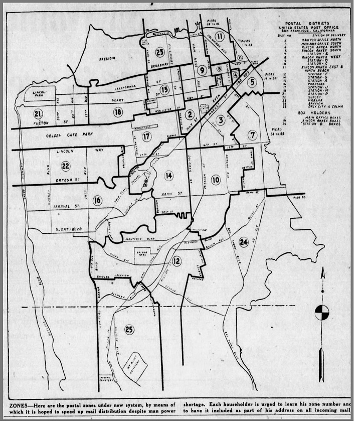
And one from November 1961 (note that the numbers are not zone numbers):
And from July 1963:
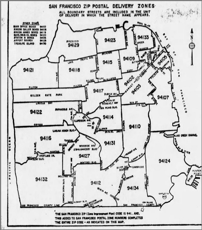
I also read that the 1967 Pacific Telephone Directory for San Francisco, including Brisbane, Colma, and Daly City by Sydney Worthington has a postal zone map.
Another thought is that telephone directories likely listed the postal codes of businesses, so it might be possible to "back-solve" the zones from 1970 using business addresses, although this would be rather tedious…
Has anyone contacted a postal historian or philatelist, e.g. the people at postmarks.org? They might know something more about the numbers on the postmarks, or at least be able to tell us where to go to learn more about S.F. postal history.
Came across this from the 1969 San Francisco Urban Design Summary.
https://archive.org/details/sanfranciscourba19691970/page/12