
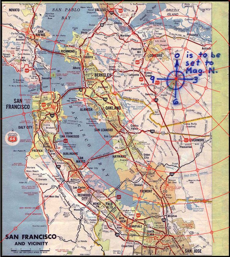
The following side-by-side comparison should be enough to illustrate the lack of convergence between what the Phillips 66 map portrays and what we will find if we contrast it to what’s actually on the ground. This is just for those who may be tempted in fallatiously thinking that interpolating some manner of conversion to geophysical coordinates (lat, long) will lead to some magical increase in precision for our searching. Of course, it doesn’t, because there is no precision to the Phillips map and so any conversion just leads us far astray.
The first figure below show a rough mapping on to the Phillips map to pick out random locations along each of the appropriately oriented ‘hour’ radials from Mount Diablo according to the given map scale of 6.4 miles to one inch. For the compariso figure, I have taken these same points and used the code offered by @coder1987 to generate the corresponding latitude/longitude pairings for the same points. The pairings have then been entered into a modern Google mapping in order to have Google generate these for us.
Irrespective of numerous issues of potential simple scale mis-matches, the stand out feature is just how badly the two methods disagree on simple bearings.
Here’s the Phillips mapping firstly:
“This isn’t right! It’s not even wrong!”—Wolfgang Pauli (1900–1958)
And next the Google mapping:
“This isn’t right! It’s not even wrong!”—Wolfgang Pauli (1900–1958)
[Hhm. Forgot about the editing time-out there.]
The comparison, amongst other things, shows that the Phillips 66 is not even correctly aligned on map north to start with.
“This isn’t right! It’s not even wrong!”—Wolfgang Pauli (1900–1958)

You have demonstrated that the Phillips 66 map is geometrically distorted. I agree. That is precisely why you should not be using it as a plotting surface.
Here is the logical structure of your argument as I understand it:
- The Phillips 66 map is poorly aligned to real terrain.
- My code converts cipher parameters to GPS coordinates using Haversine forward projection.
- The two methods disagree on where points land.
- Therefore, the Haversine method is unreliable.
Step 4 does not follow from steps 1–3. It is the wrong conclusion. The correct conclusion is:
If the Phillips 66 map is distorted (which you have now shown it is), then any point plotted on it with a ruler is plotted on a distorted surface, and the ruler-on-map result is the one that diverges from reality — not the mathematical one.
The cipher does not encode a drawn line on a map. It encodes three abstract numerical parameters:
- An origin: Mt. Diablo summit (a known, surveyable point on Earth’s surface)
- A bearing: Clock hour 10 → 300° magnetic → 317° true (after applying the 17°E declination from NOAA)
- A distance: 3⅜ inches × 6.4 miles/inch = 21.6 miles
These three values define a unique point on the surface of a sphere. The Haversine forward projection computes that point. This is not an “anachronistic” modern technique — it is the mathematically correct way to answer the question “where is the point 21.6 miles from Mt. Diablo at bearing 317°?” The answer to that question does not change based on whether you have a GPS device or a gas station map. The point is where it is.
When you place a ruler on the Phillips 66 map, you are computing the same thing, but with a distorted instrument. The map’s projection is not conformal, its north alignment is off (as you yourself noted), and its scale varies across the sheet. Every one of those distortions introduces error into your ruler-based result. The Haversine method has zero of these distortions. It uses the parameters the Zodiac gave us (origin, bearing system, scale factor) and computes directly on the WGS84 ellipsoid approximation.
The map was the communication medium — the way he told us “here is the origin, here is the scale, here is the reference direction.” Once those three values are extracted, the map has served its purpose. You do not need to keep plotting on it, any more than you need to keep looking at a recipe card while the cake is in the oven.
Your comparison of the divergence between the two methods at this distance is entirely expected for a distorted commercial road map from the 1960s, and it strengthens — not weakens — the case for using the mathematical method.
I will also note: if you trace the 10 o’clock radial using your own ruler-on-map method, you still hit the Lake Herman Road corridor. The two methods disagree on the precise landing point, but they agree on the general area. That is because the bearing is correct, and the distortion is mostly a scaling/rotation artifact. The mathematical method simply refines the imprecision that the ruler method introduces.
Finally, the validation of the method is not whether it matches a ruler mark on the Phillips 66. The validation is what you find at the computed coordinates. The Haversine projection lands 254 meters from a 100-foot equilateral triangle that points north, on a hillside next to Lake Herman Road, 1.15 miles from Blue Rock Springs. That is what the cipher decoded to, and that is what is on the ground.
If the ruler-on-map method produces a result with nothing of interest at the destination, and the Haversine method produces a result with a triangular anomaly next to the Zodiac’s first crime scene road, then the question of which method is more valid has been answered empirically.
Radar will tell us if something is buried there.
You have demonstrated that the Phillips 66 map is geometrically distorted. I agree.
That’s all I wanted to demonstrate, nothing more.
Occasionally you come across the notion that it is not so, and that Google Maps gets you to the same place just with greater detail.
That is precisely why you should not be using it as a plotting surface.
We are specifically directed to mark “# inches along the radians.” Is there anywhere else that we could do so that would make any sense? Inches along the ground wouldn’t get you beyond the toe of your boots at the Mount Diablo viewing station.
“This isn’t right! It’s not even wrong!”—Wolfgang Pauli (1900–1958)
Suppose, @coder1987, that we pause for a minute to try and get some sense of the original steps that The Zodiac was required to undertake in 1970 that would permit their reconstruction, in reverse, from your proposed method of solution.
If we start with the input and output, in your code you start with a direction along the tenth radian (so to speak), where the zeroth radian marks the direction of Magnetic North at the time, with the whole centred on Mount Diablo at some convenient point. Along with this you have some distance in inches also. From this, we proceed through the steps you describe to ultimately reach the specification of a near-precise lat./long. pair that permits the original site to be identified using modern mapping applications. Would it, then, be fair to suppose that you would have had The Zodiac start with these very lat./long. coordinates as his input, and then the work towards a bearing and a distance such as those we have to start with?
If this is reasonable (and please suggest alternatives, if not), then he would have needed some means of obtaining two lat./long. coordinates, the one for Mount Diablo’s summit – probably not difficult, owing to the detailed geographic surveys undertaken in the area even from the pioneer days – and one for a trough under the Somerset Tanks. I suppose this latter could be readily achievable to some minimal precision, at least. (I’ll let you suggest exactly how.) But, from these data, he now needs two things. He needs the direct geodesic distance between the two endpoints and a bearing that picks up the one from the other. (Are these two features at all intervisible? I haven’t checked.)
Now, he could get both these values readily from some well-scaled geographical survey map, at the same time he went to research the lat./long of Diablo, and could equally as easily given us this very map instead of the Phillips, and all would be straightforward. Instead, however, he brushes up his skills in spherical trigonometry and buys himself a high-spec slide rule and proceeds to trudge his miserable way through the Forests of Haversine, slide rule in hand like a weapon against the wolves.
Once back out into the sunlight and, fortuitously, whilst about to bemoan the awkward angle that he needs to encode in his cipher, he realises that a correction for Magnetic North could just about get the difficult direction onto the 10th hour of a suitably aligned clock and not have to worry about finer degrees. Next, he notes the distance, which comes out at about 21.5 miles, but he doesn’t want to have to encode “TWENTYONEANDAHALFMILES” in his cipher, that’s too long. So, he has an idea. He picks up another map – not the accurate one he may have consulted earlier – but a Phillips 66. He notices a scale on there of 6.4 miles to the inch and, even though he is going to make no other use of the map, he takes up the scale alone, does some more calculations, and encodes “INTHREEANDTHREEEIGHTS.” Much simpler now. That is, except for the fact that he now has to mail the map as well as the cipher, else we’d never know what scale he had chosen in his conversion.
Of course, we don’t get it. So he has to prompt us and tell us that we need to decipher a number of inches along his imagined radius that isn’t on the map that he gave us whilst hoping that we won’t ignore the scale in the bottom left-hand corner that we will need to convert to a distance that also isn’t on the map.
And it’s just as well he did, otherwise we’d never have gotten anywhere with the solution, even to this day.
“This isn’t right! It’s not even wrong!”—Wolfgang Pauli (1900–1958)
We are specifically directed to mark “# inches along the radians.” Is there anywhere else that we could do so that would make any sense? Inches along the ground wouldn’t get you beyond the toe of your boots at the Mount Diablo viewing station.
I find it worthwhile speculating on just exactly how this would have proceeded – and, indeed, have been expected to proceed – were The Zodiac’s skills in cipher composition such that he could produce, for the bomb location, one which was actually amenable to direct cryptographic solution. Let’s imagine LE, after a couple of weeks, is handed a verified solution that gives them, say, a bearing in clock hours from magnetic north and a distance in inches; which could have happened, certainly, and it is not difficult to argue that this would have been The Zodiac’s expectation.
So, in this scenario, we can ask ourselves what LE are going to do next? Where are they going to be applying these coordinates? What are they going to be using as their “plotting surface?”
Recent discussion here has, as seen, focussed on two such possible “surfaces.” The one is simply the map that LE was given. The second exists in some mental mathematical space of high precision that doesn’t have its counterpart in actual physical space (or time, for that matter).
The assignment: imagine and describe how, as the begrudged office nerd in 1970, you are going to verbalise getting the officers to put down the map.
“Out of my cold, dead hands” is probably the last thing our office boy would hear before he was assisted out the door.
“This isn’t right! It’s not even wrong!”—Wolfgang Pauli (1900–1958)
You’ve constructed an entertaining narrative, but you’ve made it backwards. Let me correct the direction of operations, because this is the crux of where your argument fails.
The Zodiac did not start with coordinates. He started with a shovel.
He knew where the site was because he chose it. He stood on Lake Herman Road, the road of his first attack, and he knew exactly where the triangle was. The encoding process was trivial:
- Open the Phillips 66 map.
- Place a ruler from Mt. Diablo to the site.
- Read off: ~3⅜ inches, 10 o’clock direction.
- Encode those two values into 32 characters.
No Haversine. No slide rule. No spherical trigonometry. He used a ruler on the map, exactly as you insist. We agree on this completely.
Now here is where you keep making the wrong turn. You are arguing that because he used a ruler on the map, we must also limit ourselves to a ruler on the map. But that does not follow. The question for us is not “how did he encode it?” but “where does 3⅜ inches at 10 o’clock from Mt. Diablo actually point on the Earth’s surface?”
A ruler on a distorted map gives you an approximate answer. The Haversine formula gives you the precise answer. Both answers land in the Lake Herman Road corridor. They disagree by 5–6 km, which — as you yourself have now demonstrated — is the Phillips 66’s distortion error, not ours.
And here is why precision matters: at the ruler-on-map resolution, you are searching a multi-kilometer swath of countryside. At the Haversine resolution, you land 254 meters from a 100-foot equilateral triangle pointing north, on the same road. The mathematical method did not lead us “far astray.” It led us to the landmark.
As for your 1970 LE scenario: Yes, in 1970, detectives would have used the map and a ruler. They would have arrived in the Lake Herman Road area and started looking around. And when they got there, they would have found a 100-foot equilateral triangle that is visible from the road. That is the entire point of the landmark — it is the ground truth marker that bridges the gap between map-scale imprecision and a specific site. You don’t need GPS precision when there’s a 100-foot triangle on the ground telling you where to look.
The map gets you to the neighborhood. The math confirms the address. The triangle is the front door.
Your reductio argument about the Zodiac trudging through “the Forests of Haversine” refutes a claim I never made. I have never suggested the Zodiac used spherical trigonometry. He used a ruler. I used mathematics. We arrived at the same road.
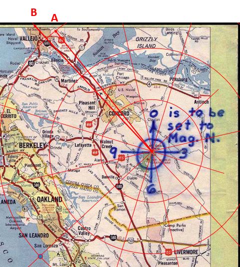
I’m going to have to offer my apologies here, which I will do at the outset, because I find myself simply unable to garner any logical sense from what you are proposing here, which is surely my bad. I will include a figure so that I can keep track of my confusion.
The encoding process was trivial:
- Open the Phillips 66 map.
- Place a ruler from Mt. Diablo to the site.
- Read off: ~3⅜ inches, 10 o’clock direction.
- Encode those two values into 32 characters.
No Haversine. No slide rule. No spherical trigonometry. He used a ruler on the map, exactly as you insist. We agree on this completely.
So, on the basis that I’m being told that we agree completely here, I interpret this as The Zodiac was clear that he had chosen the location at A, easily locatable on the map with a compass and ruler, but for some reason he chose to give us the map coordinates for the point B, on the opposite side of the I80, somewhat further north and, actually, just off the map. (WT…?) He didn’t just encode the coordinates for A, then, and why?
In fact, the only demonstrable connection between A and B, as you have demonstrated clearly, is that, if you take the Diablo map coordinates for B, convert them using precise spherical trignometrical methods into latitude and longitude, you get to the location of A on Google Maps. They are not “roughly the same place” or “kinda close together.” They are wholly separate destinations.
If you look on the ground at where B is shown on the map – to the west of the I80 and east of Solano Boulevard – you will very much find that your are in the heart of Vallejo. This is just how maps work, whether they are precisely laid out or as vague as you want. We locate our destination by the indicated features it is between. (You would get so confused trying to decipher the rail network map on the London underground. Seriously.)
But – and again we agree – The Zodiac doesn’t know anything about spherical trigonometry, doesn’t know anything about the specific anomalies of the Diablo Map in relation to the terrain on the ground. So (WTA…?) how is he supposed to know that in the future, if we manipulate the measured coordinates for on the map for central Vallejo in the way you have presented, we would get “precisely” (your word) to the location he had intended all along, which he could just have marked and measured from the map? You couldn’t presume any such a premonition without having to have the author fully aware of exactly how the Phillips and the ground differ and the mathematics to back it up.
I’m glad I did make the point previously about my reason for highlighting the discrepancies between the Phillips 66 and Google maps, because this appears to be exactly what you are evidencing here. To recall:
“Occasionally you come across the notion that … Google Maps gets you to the same place just with greater detail.”
Now here is where you keep making the wrong turn. You are arguing that because he used a ruler on the map, we must also limit ourselves to a ruler on the map. But that does not follow.
Absolutely yes it does!!!!!
(Try and apply your ‘logic’ to the Piri Reis.)
The question for us is not “how did he encode it?” but “where does 3⅜ inches at 10 o’clock from Mt. Diablo actually point on the Earth’s surface?”
It falls about where the shadow of your nose would appear ahead of your foot at some time just after noon on Mount Diablo.
Absolutely, wow.
Still, thank you for the clarification of this, though. I had always wondered how the thinking went with such ‘analyses’.
“This isn’t right! It’s not even wrong!”—Wolfgang Pauli (1900–1958)
Hi again,
I have read your response carefully, and I believe you have genuinely confused yourself. The confusion is instructive and I think it’s the same confusion that has kept this cipher unsolved for 55 years.
You are not describing my method. You are describing a method I have never proposed.
You write: “for some reason he chose to give us the map coordinates for the point B, on the opposite side of the I80.”
No. He didn’t “give us coordinates for B.” He gave us a cipher that decodes to three parameters: direction 10, distance 3⅜, unit inches. Those three values, combined with the map’s own stated scale (6.4 mi/in) and the magnetic declination he told us to apply (Mag. N., measured at 17°E for the region in 1970 via NOAA), define a real-world location. There is no “point A” and “point B.” There is one set of instructions and one destination. Whether you compute that destination with a ruler on paper or with trigonometry on a computer, you are answering the same question. The ruler gives an approximate answer. The math gives a precise one. Both land in the Lake Herman Road corridor. They differ because the map is distorted, as you yourself proved.
You keep insisting the Zodiac would need to understand spherical trigonometry. He would not. He used a ruler. He measured 3⅜ inches. He saw it landed near Lake Herman Road. That is all he needed to know. I am not claiming he computed Haversine projections. I am claiming that when we do the math properly, using the parameters he gave us, we land 254 meters from a 100-foot equilateral triangle pointing north, on a hillside beside Lake Herman Road — the road of his first murder. That is what the math produces. I did not choose this location. The cipher and the Zodiac’s crime scene locations chose it.
Your Piri Reis analogy is a false equivalence. The Piri Reis map has no stated scale, no stated projection, no stated origin, and no accompanying cipher with explicit instructions. The Phillips 66 has all four. The Zodiac told us: origin (Mt. Diablo), reference direction (Mag. N.), distance unit (inches), and scale (printed on the map legend). These are sufficient to define a unique point on the Earth’s surface, whether you use a ruler or a formula.
Now let me address what you are overlooking, because the list is long.
You have spent years analyzing this cipher. I have read your threads — “Attacks on the Z32,” “Approaching the two remaining ciphers as chess problems,” “Z13 as Z32 Mk. I,” and “Decoding the location of The Zodiac’s bus bomb without Google.” I respect the depth of your work. But here is what your own record shows:
In 2022, you proposed this solution to Z32.
You had no code. You had no exhaustive search. You had no ranking criterion. You had no corroborating physical evidence at the destination. You had no landmark. You had no geometric alignment. You subjectively selected it and presented it as your best candidate. I have no issue with that — it was a thoughtful attempt.
So your own position is that you believe in a specific location, based on interpretive reasoning and personal conviction, with no physical corroboration and no falsifiable evidence. And your objection to my work is that I should not be believed, despite having an exhaustive computational search of 2 million candidates, three independent constraint filters, a proximity-based ranking algorithm, and a 100-foot equilateral triangle on the ground at the decoded coordinates.
You also wrote, on these very forums: “Your code, @coder1987, models your assumptions and I am more than confident it does so admirably.” You are not disputing the code. You are not disputing the constraints. You are not disputing the plaintext. You are disputing the projection method — and only the projection method — because it produces a result that is not your result.
In your own 2022 thread, you wrote: “we have either been presented in the Z32 with a sufficiently constrained problem that is capable of producing a uniquely defined solution, or we are wasting our time.” I built the software that tests this. I tested 2 million candidates. 99.99% were eliminated. The top-ranked survivor points to Lake Herman Road, next to a triangular anomaly. That is the uniquely defined solution you said must exist.
You also wrote in 2022: “all that is needed is just some help from a simple word solving programme and a little persistence besides.”
That is what I built. You are now arguing against the output of the very tool you said was needed.
Let me close with this.
Your map-distortion argument proves that the Phillips 66 is an imprecise plotting surface. I agree. That imprecision means a ruler on the map gives you a search area, not a search point. Both your ruler result and my Haversine result fall within the same area — the Lake Herman Road corridor. The difference is that within that area, the mathematical projection lands 254 meters from a physical landmark that matches the morphology of a symbol in the ciphertext. Your ruler-on-map method lands in central Vallejo with nothing to show for it.
If your argument is correct — that we should only use a ruler on the map and accept the imprecision — then the answer is still Lake Herman Road, and the triangle is still there when you arrive. The Haversine formula does not change the destination. It sharpens the resolution. And at that resolution, you find something remarkable.
I remain open to any of the five falsification criteria I listed earlier. To date, none have been met. What has been met is an extended series of interpretive objections, none of which engage with the code, the constraints, or the physical evidence on the ground.
The next step is not more forum posts. It is ground-penetrating radar.
What I could imagine is that he started off writing “Radians + inches along the Radians,” paused after “+ in…” realising that he needed to interpolate “#” to convey his precise intention, did so, then went back to completing the sentence introducing an unintended skip.
A definite possibility.
You write: “for some reason he chose to give us the map coordinates for the point B, on the opposite side of the I80.”
No. He didn’t “give us coordinates for B.” He gave us a cipher that decodes to three parameters: direction 10, distance 3⅜, unit inches.
Direction 10, 3⅜ unit inches, on what map???? It’s in inches, it must come from a map, and the map must be scaled at 6.4 mi/in, just like the Phillips.
He gave us the Phillips. We look no further.
In 2022, you proposed this solution to Z32.
You had no code. You had no exhaustive search.
Thanks for the bump.
This was my write up on this forum, which was intended to provide an alternative, direct approach to the proposal which was originally worked through via candidate exhaustion limited by form assumptions and using, I recall, an Excel spreadsheet, as it was sufficient for the purpose. That original work was presented in detail, step by step, on Tom Voights forum. I don’t frequent that forum now and haven’t since Dave Oranchak picked this one up from Morph.
“This isn’t right! It’s not even wrong!”—Wolfgang Pauli (1900–1958)
I remain open to any of the five falsification criteria I listed earlier.
This is peer review. The criteria for falsification are chosen for you.
“This isn’t right! It’s not even wrong!”—Wolfgang Pauli (1900–1958)
“Direction 10, 3⅜ unit inches, on what map???? It’s in inches, it must come from a map, and the map must be scaled at 6.4 mi/in, just like the Phillips. He gave us the Phillips. We look no further.”
We agree. The scale comes from the Phillips 66: 6.4 miles per inch. I use that exact scale. It is hardcoded in my solver. 3⅜ inches × 6.4 mi/in = 21.6 miles. The origin is Mt. Diablo. The bearing is clock hour 10 adjusted for magnetic declination. These three values — origin, bearing, distance — all come from the Phillips 66 and the Zodiac’s own annotations. I am not “looking further” than the Phillips. I am extracting the parameters the Phillips provides and computing where they point.
A ruler on the map answers the question “where does this line land on this piece of paper?” The Haversine formula answers the question “where does this line land on the Earth?” Both use the same inputs. One is approximate. One is precise. Both land in the Lake Herman Road corridor. The precise one lands 254 meters from a 100-foot equilateral triangle.
You keep framing this as though I am ignoring the map. I am not ignoring it. I am reading it — extracting its scale, its origin, its reference direction — and then computing the result without inheriting its printing distortions. That is not looking further than the Phillips. It is looking more carefully at what the Phillips tells us.
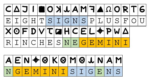
As for your own solution: you say it was originally worked through on Tom Voigt’s forum using an Excel spreadsheet with “candidate exhaustion limited by form assumptions.” That is, in principle, the same class of approach as mine — generate candidates, apply constraints, filter. The difference is that my search space is 6.6 million candidates across 20 templates with three independent constraint filters and a reproducible ranking algorithm, and it is publicly auditable on GitHub. Your work on the other forum is, by your own account, no longer accessible. The write-up you posted here on this forum — EIGHTSIGNSPLUSFOURINCHESGEMINI — is what is available for evaluation, and I addressed it directly in my previous post. It requires four subjective assumptions, a position-transposed character, a reverse-K encoding not found in any other Zodiac cipher, cross-cipher key sharing, and it points to a location with no corroborating physical evidence.
Mine requires a computer, the Zodiac’s own hints, and a willingness to look at what is on the ground when you get there.
We have now been going back and forth for quite some time, and I want to be respectful of your time and everyone reading this. The positions are clear. You believe the map surface is the final authority. I believe the map’s parameters are the final authority. Both approaches land in the same general area. Only one of them resolves to a location with a 100-foot triangular anomaly on the ground, next to the Zodiac’s first crime scene road.
I don’t think we are going to convince each other through further posts. The next step is not another reply, but the quick radar check. If the triangle contains buried material connected to the Zodiac case, this debate is settled. If I had the ability/authority to perform this check, it would have already happened.
Thank you for the engagement, shaqmeister. I see that you came back from years of activity to discuss this with me. This has been the most substantive discussion of Z32 methodology I have seen on any forum, and I do appreciate that. I will be addressing your map distortion objection in version 3 of my paper, and you added value by bringing it up.
I remain open to any of the five falsification criteria I listed earlier.
This is peer review. The criteria for falsification are chosen for you.
Peer review evaluates the work on its own terms, then presents specific, substantive objections. It does not simply announce “I am peer review” and declare authority.
In the weeks we have been discussing this, you have not identified a bug in the code, demonstrated a biased lexicon, corrected the map scale or declination values, documented the origin of the triangular anomaly, or produced a competing solution that survives the same constraints with independent corroborating evidence. Those are not arbitrary criteria I invented to shield myself. They are the obvious ways you would falsify any computational result: show the inputs are wrong, show the algorithm is wrong, or show that a better answer exists. That is how peer review works in every quantitative field.
What you have offered is: the Phillips 66 is distorted (agreed), the Zodiac didn’t know Haversine (agreed), and you personally prefer a different solution (noted, but EIGHTSIGNSPLUSFOURINCHESGEMINI has no code, no exhaustive search, no ranking criterion, and no physical evidence at its destination).
Peer review that consists entirely of “I don’t like your projection method” without engaging with the code, the constraints, or the 100-foot triangle on the ground is not peer review. It is an opinion. You are entitled to it, but let’s not dress it up.
The code is public. Run it. Break it. Show me the bug. That is peer review.
