
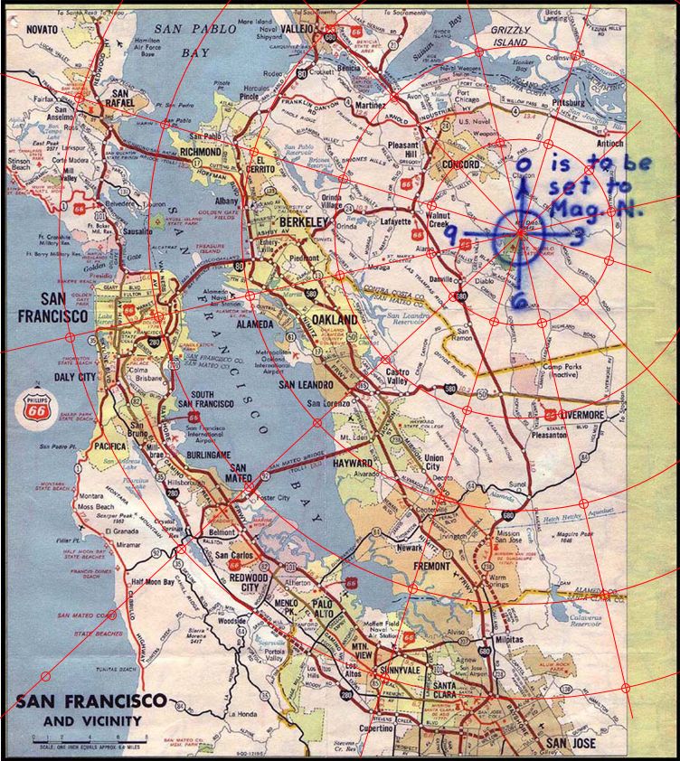
99 times out of a hundred, when we start out on trying to decode the Z32 cipher, we forget what exactly it is we have been given, and what exactly we are expected to do with it. As to the former, we are handed a cipher and a very specific Phillips map. The map gives us a compass rose to be aligned on magnetic north and an unconventional direction indicating its division into twelve sectors. A later clue adds that we are interested in a distance, on the map, measured in inches. For tools, aside from deciphering the cipher itself, we thus require only 1.) the map, 2.) a protractor to mark out angles and 3.) a ruler marked in inches. As to what we are to do, we are to find the location of a bomb detailed in several places and, if actual existent, primed at the side of a road somewhere along a school bus route.
But here’s the thing – and this is where most attempts go astray right from the start. We have to first ask where it is that we are searching for our bomb location using what we have been given, and the ubiquitous answer to this appears to be “on the ground.” Of course this is, however, not the case at all.
Surely, were we to one day reach the actual solution, we will have a point identified on the solid earth. That said, however, our process of searching involves only our proposed cipher solution and the Phillips 66 map.
In and of itself, the map we are given is very poorly detailed and sloppily scaled. Despite the almost universal assumption that a translation of any proposed solution into lat/long or GPS or any other coordinates on the ground will match the equivalent point as marked on the map with the same bearing and distance from Mount Diablo, it won’t!
Even a cursory attempt to create a semi-transparent overlay of the Phillips map on top of the equivalent terrain on, say, Google Maps, will show just how badly the attempt fails. And, in 1970, we didn’t have Google Maps either. Basically, to be authentic in our search we just need to step back from the modern day, close down our Maps application, and stick with the Phillips map that we were actually given.
There are, essentially, two possibilities for what we are looking for. Firstly, it may be the case that all we have been given in the cipher is the relevant coordinate pair for the feature we are guided to identify or, secondly, we are directed to a much more general area and given an additional clue as to the specific ground feature sought.
In the first instance, the map must give us everything. The feature looked for must be actually present on the map. Of course, there are very few features actually shown – the bomb site must be somewhere along a pretty major highway or main road – and thus this realisation alone must cause us to give especial consideration to the second possibility. In the latter instance, then, we require something extra, and very likely the last characters of the cypher would give us this further clue.
For example, suppose the intended location was back at Blue Rock Springs. With very little precision – since the map doesn’t permit precision of any kind – we might find that the decoded coordinates point from Mount Diablo over Benicia toward eastern Vallejo in general. That, in itself, wouldn’t give us much at all. But suppose something like ‘LAZULUM’ were added at the end, then now – and only now – we can pin down something not immediately present on the map.
The point is, however we are to proceed, we simply have to get away from thinking about coordinates, bearings, distances on the ground. If that had been the intention, we would have either been given a better map or, more likely, none at all. Essentially, in this one instance, if not in others, Google is actually your Nemesis, not your friend.
“This isn’t right! It’s not even wrong!”—Wolfgang Pauli (1900–1958)

Let me make sure I understand your argument. The Zodiac gave us an origin (Mt. Diablo), a bearing system (clock hours from magnetic north), and a scale (6.4 miles per inch). Your position is that after extracting these three values, we should only apply them on the distorted paper map they came from, and never compute where that point actually falls on the Earth’s surface.
This is like saying: if someone hands you a treasure map drawn on a napkin that says “200 paces north of the old oak tree,” you must search by placing a ruler on the napkin. You must not walk to the actual oak tree and take 200 actual paces north, because that would be “anachronistic.”
The map is the communication medium, not the search surface. It tells us three numbers. Once we have those numbers, the map has done its job. The point 21.6 miles from Mt. Diablo at bearing 317° exists on the surface of the Earth regardless of whether you compute it with Haversine or eyeball it with a gas station map. The math doesn’t move the point. It just finds it more accurately than a crooked map does.
You say the Phillips 66 is poorly detailed and sloppily scaled. I agree — you’ve demonstrated this yourself with your own overlay tests. So your conclusion is… we should confine ourselves to the sloppy instrument? That’s not methodological rigor. That’s methodological handcuffs.
And here’s the part I find amusing. You’ve spent several posts arguing that the map is too imprecise to convert to real-world coordinates. Then you propose we should search for our answer exclusively on that same imprecise map. You can’t have it both ways. Either the map is precise enough to identify a location, in which case mathematical projection will get you to the same place with less error — or it isn’t precise enough, in which case your ruler-on-map method fails for the same reason you claim mine does, except with worse accuracy.
I want to lay something out plainly, because I think the readers following this thread deserve clarity on what has actually happened here over the last week.
You have:
Argued that the Phillips 66 map is too distorted to trust — then argued we must only use that same map. Proposed that the criterion for a valid solution is whether it matches the bomb diagram location — then, when shown that a hillside depression at the decoded coordinates meets that criterion, pivoted to cattle watering holes. Told readers not to be “bamboozled” by the suggestion of GPR — a standard, non-invasive archaeological survey tool — as though scanning the ground for subsurface anomalies is somehow unscientific. Asked me to prove the triangle’s origin through newspaper archives and landowner interviews, while offering no explanation yourself for how a 100-foot equilateral triangular depression with sharp edges appeared on a hillside next to Lake Herman Road between 1964 and 1982.
You have not identified a single error in my code. You have not found a single mathematical mistake in my projections. You have not explained the triangle. What you have done, consistently, is argue that the question should remain permanently open and that no physical test should ever be conducted.
That is not skepticism. Skepticism proposes a test and accepts the result. What you are doing is the opposite — arguing against the test itself. You are not saying “your evidence is wrong.” You are saying “let’s not check.”
I published my code. I published my data. I published my methodology. I told you exactly how to falsify my result. You responded by telling people not to get bamboozled.
I’ll ask you directly: what would convince you? Not a hypothetical — a specific, concrete piece of evidence. Because if the answer is “nothing,” then this isn’t a methodological disagreement. It’s a decision to not engage with the result.
This is like saying: if someone hands you a treasure map drawn on a napkin that says “200 paces north of the old oak tree,” you must search by placing a ruler on the napkin. You must not walk to the actual oak tree and take 200 actual paces north, because that would be “anachronistic.”
And if the map drawn on the napkin says “2 inches north of the old oak tree?”
“This isn’t right! It’s not even wrong!”—Wolfgang Pauli (1900–1958)
Argued that the Phillips 66 map is too distorted to trust
I think the correct reading would have me arguing that the distortion of the Phillips 66 is such that 4 inches west on the map and 25.6 miles west on the ground won’t take you to the same place.
“This isn’t right! It’s not even wrong!”—Wolfgang Pauli (1900–1958)
I think the correct reading would have me arguing that the distortion of the Phillips 66 is such that 4 inches west on the map and 25.6 miles west on the ground won’t take you to the same place.
I apologise, I forget to give the source for where this observation was discussed, which is here.
“This isn’t right! It’s not even wrong!”—Wolfgang Pauli (1900–1958)
There was also a detailed analysis of the distortion offered here. (That said, I did mess up the presentation owing to the editing timeout.) As relevant to this thread, here is the comparison I posted there.
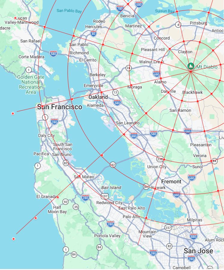
Both figures incorporate a magnetic north correction of +17° in conveying 12 radii out from Mount Diablo at 30° separation. The top figure adds arcs at a radial separation of 1 inch, the second at a radial separation of 6.4 miles.
“This isn’t right! It’s not even wrong!”—Wolfgang Pauli (1900–1958)
And here’s the part I find amusing. You’ve spent several posts arguing that the map is too imprecise to convert to real-world coordinates. Then you propose we should search for our answer exclusively on that same imprecise map. You can’t have it both ways. Either the map is precise enough to identify a location, in which case mathematical projection will get you to the same place with less error — or it isn’t precise enough, in which case your ruler-on-map method fails for the same reason you claim mine does, except with worse accuracy.
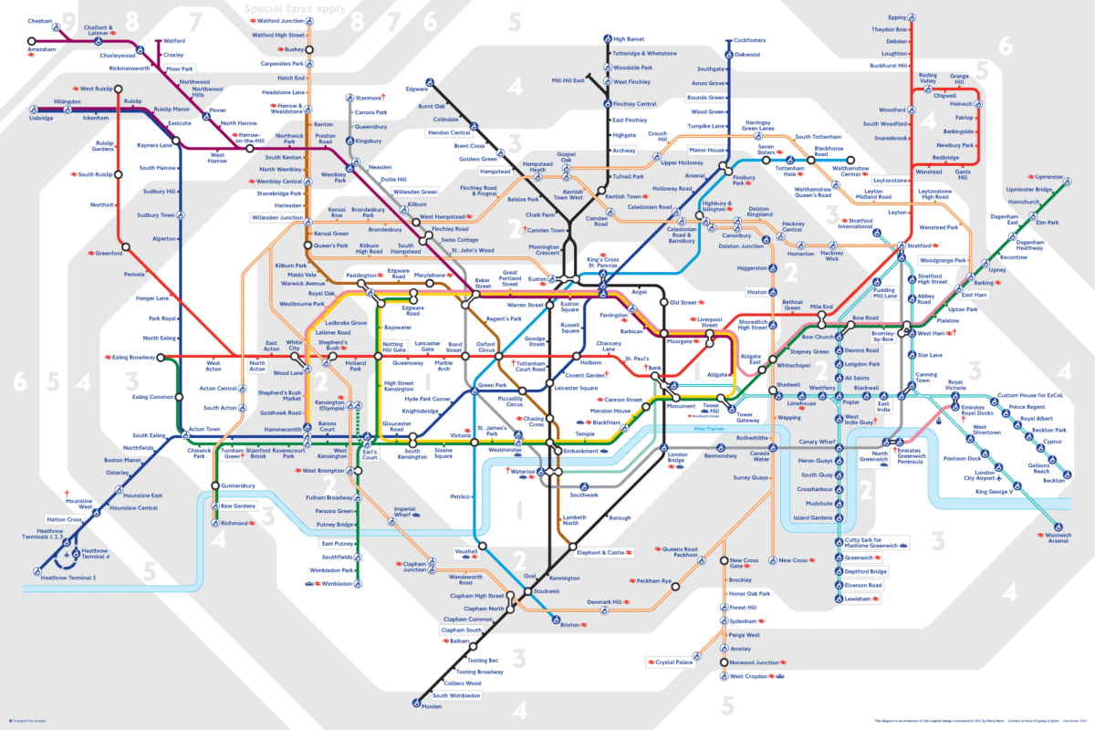
The following is also a geographically ‘imprecise’ map. Unlike the Phillips 66 map, the London Underground map conveys zero correlation to the actual locations on the ground. It is, in this sense, as ‘imprecise’ as you could want. All the same, as a map, it is admirably suited to its purpose in helping people use the tubes to get to their destinations. The same can be said for the Phillips 66 map. For road-trippers in 1970 in the Bay Area, they would have had no difficulty in getting to their broad destinations using this map.
Like the Phillips map, I could send it to you along with a note (encoded in a cipher, if you like), stating that the destination that I want you to meet me at is 2 inches straight down from the top and 3 inches in from the left. Assuming I’d measured this accurately with my ruler, you would have our meeting point.
Were you, however, to take me as proposing you mark off on the ground a location 2 of any distance units whatsoever south, and 2 of the same units east of the geographical location corresponding to the top-left corner of the map, we would not meet that day.
How you are to interpret my specific instructions, according to which method you use to apply them – map or ground – you need only heed the distance units given: “inches,” its on the (imprecise) map, “miles,” you could then assume the geographic approach. There’s no interchange between the two, however, that could give the same location.
“This isn’t right! It’s not even wrong!”—Wolfgang Pauli (1900–1958)
@shaqmeister Hello, the London subway map you have posted is irrelevant to the Z32 cipher.
The solution you proposed landed in the water, when projected from the Mt. Diablo summit, adjusted for 1970’s magnetic decliniation. Zodiac referred to this cipher as The Mount Diablo Code.
Regardless, I am impressed by your mental gymnastics, such as the suggestion that the 100 foot triangle by Lake Herman Road that points north and matches the repeated triangle in the ciphertext was constructed for the purpose of watering the cows.
Had you properly projected your own proposed solution, while in the water, it was quite close to the Bay Bridge. In which case I would imagine the narrative would become, “he planned to attack the bridge with Z32, and I found the proof”. No hills. He didn’t bury anything in the water. Sorry.
I don’t know why you used the words SIGNS and GEMINI. RADIANS and IN(CHES), as the Zodiac himself suggested, is far more reasonable.
It is similar to what happened with Oliv, they were attracted to the thought of the Alcatraz candidate being their subjectively selected favorite, because they considered it to be an interesting narrative.
I don’t disagree with that. They also noted that the Lake Herman Road candidate seemed promising. I agree with that. Oliv92 didn’t check the satellite imagery, or they would have found this landmark 5 years ago. And if they would have seen the landmark, I think they would have realized all they needed to do was rank by proximity to confirmed Zodiac crime scenes as the final step to arrive at a unique solution.
@shaqmeister Hello, the London subway map you have posted is irrelevant to the Z32 cipher.
This point is worthy of further exploration, but you say nothing to support your statement here.
The remainder is, however, off topic.
“This isn’t right! It’s not even wrong!”—Wolfgang Pauli (1900–1958)
Had you properly projected your own proposed solution, …
No ‘proposed solution’ of mine, or anyone else’s, has been put forward in this thread. All such proposals as have been offered previously have their own threads. Can we vere away from blatent thread highjacking please? Thank you.
“This isn’t right! It’s not even wrong!”—Wolfgang Pauli (1900–1958)
It is similar to what happened with Oliv, …
Ditto …
“This isn’t right! It’s not even wrong!”—Wolfgang Pauli (1900–1958)
@shaqmeister Hello, the London subway map you have posted is irrelevant to the Z32 cipher.
This point is worthy of further exploration, but you say nothing to support your statement here.
The remainder is, however, off topic.
Zodiac didn’t operate in London. He operated in Vallejo, near Lake Herman Road and Blue Rock Springs.
