
Saying “no” isn’t an argument.
Apologies, @coder1987, I’ve probably confused you. I was merely saying “no” to the assertion that I am expecting a description of the terrain to be found within the decoded plaintext. We already have that, of course, and in quite some detail.
“This isn’t right! It’s not even wrong!”—Wolfgang Pauli (1900–1958)

This is your strongest argument yet, and I want to acknowledge that. You’re reading the bomb mechanism sketch as an engineering specification — sensor B needs line-of-sight to sensor A, both need proximity to the road, the slope needs to face the right direction for sunlight, and the whole apparatus must be within a few meters of a passing bus. That’s a careful, functional reading of the sketch, and I respect it.
But you’re conflating two different questions.
The first question is: what does the cipher say? That’s answered by the constraint satisfaction analysis. 32 characters, three lock conditions, map bounds. The cipher gives coordinates.
The second question is: does the site at those coordinates have features consistent with what the Zodiac described in his letters? That’s a site survey question. And crucially, the paper doesn’t claim the triangle is the bomb. It claims the cipher points to this area, and something anomalous is there. Whether the micro-terrain six inches from the road satisfies every engineering detail of a bomb sketch drawn by a man who also admitted the design might not work — that’s a question for ground-penetrating radar and a site visit by authorities, not for satellite imagery and forum debate.
You’re essentially arguing: “I won’t accept coordinates unless I can verify the bomb’s trigger geometry from Google Earth.” That’s not a standard any 32-character cipher could meet. The cipher gets you to the road. The road is Lake Herman Road. The terrain matches the sketch at the macro level. What happens next requires people on the ground. If they find physical evidence connected to the Zodiac buried in the triangle, it is solved.
That’s a phone with a cracked screen, and you’re refusing to pick it up because it’s not in the exact room you expected.
I asked you for my phone, which doesn’t have a cracked screen, and very much is where I left it.
“This isn’t right! It’s not even wrong!”—Wolfgang Pauli (1900–1958)
This has been up for around 2 weeks now, and I haven’t received an objective falsification yet, which is a positive sign. Subjective, “I just don’t think this is the one” won’t quite cut it, as it points to a physical location that can be scanned with radar to properly make that determination.

Hi coder1987,
(My first post in about 3 years)
Your proposed solution looks good and demands further research. Adding geospatial constraints is a great idea! Take in mind, I’ve only glanced over your paper due to time constraints on my behalf. I will notify Dave and Sam of your work.
A question to you, assuming Zodiac well understood the limits of deciphering and your proposed solution is the real solution, do you think it possible he was able to infer the Z32 as being solvable?
Thank you
@jarlve Hello,
Thank you for your work on AZDecrypt, and it is very nice to see you here.
I had emailed David and Sam as soon as I published to GitHub, and tried to find your email to inform you as well (but wasn’t able to find it).
I am in the process of finalizing version 3, since I added more candidates. The one I shared here tests 2 million but it is up to 6 now. Same solution survivors. I added a slot for plausible middle connectors like “ON”, “FROM”, “AT”. So there will be an updated version out soon.
“A question to you, assuming Zodiac well understood the limits of deciphering and your proposed solution is the real solution, do you think it possible he was able to infer the Z32 as being solvable?”
I think he gave so many intentional hints that he wanted this to be solved and for this triangle to be found. Without the “Radians and inches” post script hint he gave, I don’t think it is solvable. That reminds me of one of those old “Forgot your password?” hints that were insecure. He essentially handed us all some great cribs pretty openly.
Zodiac craved attention, if he buried something in that triangle, he knows it will be on the news when they dig it up. And he’s not wrong about that
Wanted to add the only reason I became interested in this cipher was seeing you and your teams work on Z340, which inspired me to try. Using a computer was the way to go.
I only attempted this due to all the provided hints. Without those, I realize the futility and wouldn’t have bothered.
I was surprised to see that nearly ever past attempt on this cipher was done manually, except for Oliv92. I hope to hear back from them. I believe this required software. The original codebase was only 77 lines however, and not particularly complex.
That is to say, this was achievable decades ago by a regular programmer, but they wouldn’t have had Google Maps like I did to check the coordinates imagery. That was very useful here.
When I first checked the coordinates on the map, I wasn’t sure where it would land. It could have been on a house, in a body of water, but it landed by Lake Herman Road right by that triangle. And that is why I had to share it. The odds are very low of that happening, but it did.
A closing thought before bed:
Wanted to report this nefarious spam post that may have been overlooked: https://forum.zodiackillerciphers.com/community/welcome-to-the-forum-please-read/girls-in-your-town-no-verify-anonymous-casual-dating/#post-88956
And there is no rush on your review of the work. I am sure you are busy with other things, as are others. I have had it checked out by a few Computer Science professors, which didn’t spot any breaking issues. More feedback is always appreciated and welcome, with the reminder that my work is continuing with the 3rd version. It is generally the same as version 2, except that it is slightly expanded, and some general flow improvements, and aesthetic improvements to the imagery.
There is a minor error in the Discussion section regarding the 13th Hole card that I will be correcting. It is referred to as a “cartographic communication”, which was wrong. It did not include a map, and so I will be removing the word cartographic in version 3. I wanted to point this out.
I am also fine with referring to this as a proposed, unconfirmed solution. While there is some compelling evidence here, the radar test is really what I am hoping for. I have of course informed the relevant authorities back in December, but I would imagine they receive many proposed solutions to both Z32 and Z13, none of which have panned out. I can understand why proposed Z32 solutions may not receive much attention due to resource constraints.
Maybe this one will get checked out, but that part is beyond my capabilities. I think it would be worth it, because it is low effort to do a quick check. Forensic science is very good these days, and so physical evidence recovery could be a breakthrough for the case. Not saying that will happen, only that it is possible. It is also possible there is nothing buried there at all. But this is testable, as you know.
Thanks again for the message.
Wanted to address the Z32 solution proposed by Alex Baber, which has made global news:
He has no white paper, no code. His solution is subjectively selected, without testing millions of plausible alternatives.
He is trying to connect the Zodiac case to the Black Dahlia case. Authorities would have done this a long time, if it were true.
He ignores the clock hours hint in his projection, and assumes the Zodiac used the term radians correctly.
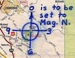
As a result, he points to a cemetery with the plaintext “ESTIMATE FOUR RADIAN AND THREE INCHES”.
Well, he got the three inches part right, but he is missing the fraction, and it is the 10 o’ clock vector from Mt. Diablo.
Seems they are hyping this up for a Netflix series selling this solution to the public.
Adding some information regarding the significance of the Mt. Diablo origin point for this projection. It turns out that Mt. Diablo is used as the origin point in the land surveying for most of the state of California. This is a very significant mountain in the context of maps/navigation.

“The Mount Diablo Meridian, established in 1851, is a principal meridian extending north and south from its initial point atop Mount Diablo in California at W 121° 54.845. Established under the U.S. Public Land Survey System, it is used to describe lands in most of northern California and all of Nevada.[1] Mount Diablo also marks the baseline at latitude 37°52′54″N.”
This mountain is used as the origin point for most of the mapping in the entire state of California. It is not just a random mountain, but rather a very significant point in the context of mapping and navigation.
The beacon on the summit is known as the “Eye of Diablo”. Reminds me of Lord of the Rings.
“The “Eye of Diablo:” an aerial navigation beacon at the peak of Mt. Diablo, looks out on one of the finest views in the world.
First installed by Standard Oil Company to assist in commercial aviation, it was originally lit by Charles Lindbergh in 1928. Eventually, the mountain’s beacon was extinguished in 1941, shortly after war was declared on Japan.”
Source: https://www.visitconcordca.com/blog/a-message-from-the-mountain/
This is probably why he drew his crosshair branding on Mt. Diablo, and refers to Z32 as the “Mount Diablo code”, and uses it as the origin point in his “radians” (radial lines) and inches coordinate system that he invented.
For what it is worth, the nature of this “anomaly” can be fairly easily investigated and clarified using the historical images feature in Google Earth Pro and taking into consideration the surrounding land profile. As will be evident in trying to get a view of the feature from Lake Herman Road, it lies in a dip which can be readily profiled on all sides. It forms what, in the UK, we would call a “marsh” area of the field, being of poor drainage and hence holding water under appropriate climatic conditions. Scanning through the historical images, we can see that during lush periods (green surrounding field) the dip is markedly waterlogged, even filled (e.g. 2013, 2015, 2016, 2017, 2022, 2025). During scorched periods, it is alternatively dried out and appears to present either a small circular hollow or hill within its bounds, which may be present owing to intentional earth-shifting in drier periods to maximise minimal rain capture. It’s boundaries are naturally marked by the paths cut by cattle trails approaching from three directions, largely consistent over time, the markedly preferred drinking spot for cattle being the east face, which is more heavily scuffed up to the edge at most times. It is of a fluid form save for the tracks defining the broad edges and undergoes seasonal flooding and scorching alternately. It is a cattle watering hole, defined at its edges by cow tracks in the terrain and further managed manually during dryer seasons. The cattle can be picked out on an image from 2023.
“This isn’t right! It’s not even wrong!”—Wolfgang Pauli (1900–1958)
Cattle watering holes are not equilateral triangles.
That’s really all that needs to be said, but let me elaborate. You’ve described a feature that holds water in wet periods and dries out in dry periods. Correct — that’s what a topographic depression does. The question was never whether it holds water. The question is why it’s shaped like a 100-foot equilateral triangle with sharp linear edges and interior angles within a degree of 60°.
Cattle do not excavate geometric shapes. Cattle trails follow paths of least resistance to water — they meander, converge organically, and create irregular scalloped edges through repeated hoof traffic. What they do not produce is three straight edges of equal length meeting at three equally-spaced vertices. You can verify this yourself: find any other cattle watering depression in the surrounding hills, or anywhere in Solano County, and compare its morphology. They’re amorphous, irregular, and rounded. This one isn’t.
You mention a “small circular hollow or hill” visible inside the triangle during dry periods. You’ve just described the concentric inner structure documented in Section 4.3 of my paper — a roughly circular region of distinct soil expression within the outer triangular perimeter. You are presenting corroborating evidence for my analysis while arguing against it.
You say the boundaries are “naturally marked by cattle trails approaching from three directions.” Cattle approach water from whatever direction they happen to be grazing. The fact that they approach from three directions is a consequence of the triangle having three sides — they walk along the edges because the edges exist. The trails don’t create the shape. They follow it.
You say the form is “fluid.” It isn’t. The triangular morphology is persistent across every image in the historical record from 1982 to 2025 — over 40 years, through floods, droughts, and seasonal cycles. A fluid natural feature does not maintain equilateral geometry for four decades.
And most importantly: the feature is absent in 1964 aerial imagery and present by 1982. Something created it in that window. Cattle don’t dig 100-foot equilateral triangles into hillsides. People with shovels do.
GPR would settle this in an afternoon. You know that.
GPR would settle this in an afternoon. You know that.
I will decide for myself what I know, thank you @coder1987.
“This isn’t right! It’s not even wrong!”—Wolfgang Pauli (1900–1958)
I presented nine specific points. You responded to zero of them.
For the readers following along: the argument that was made is that cattle watering holes are not equilateral triangles, that this feature has maintained geometric precision for over 40 years, that it contains a concentric inner structure, that it was absent in 1964 and present by 1982, and that it sits 254 meters from coordinates decoded through a constraint satisfaction method that rejected 99.9974% of 2,044,224 candidates — with all code and data published for independent verification.
The counterargument offered was “it’s a cow pond” and “I will decide for myself what I know.”
The code is on GitHub. The paper is public. Every claim maps to a line of source code. Every coordinate can be recomputed by anyone with Python installed. Nobody is being bamboozled — that word implies deception, and there is nothing hidden here.
I will not do is continue to re-litigate whether cows dig equilateral triangles. They don’t. Everyone reading this knows they don’t. And I think, respectfully, you know it too.
Adding a message for @DMW @shaqmeister and @Oliv92
If my proposed solution/methodology is validated, I am happy to acknowledge your past efforts on Z32, by name, username, or not at all. In retrospect what I am seeing with this cipher is that others were close, but collaboration and feedback was difficult to receive. I believe that if there was more collaboration, perhaps through a service like discord, this triangle would have been found awhile ago.
