
@shaqmeister Feature requests for a Javascript based version with an interactive map are definitely appreciated, and some or all of them, I can include.
One thing that I will be adding is the ability to optionally show/hide other Zodiac related points, like the payphones he used, and other suspected victim locations, like the Kathleen Johns abduction, the Santa Barbara beach attacks, Cheri Jo Bates, and Ray Davis. I already did some analysis on Ray Davis and Cheri Jo Bates. I won’t go into too much detail here, but I will be circling back to those two later.
And let people add whatever other points they would like, and see where they land, relative to his pre-existing geometry from his “official” crime scenes that we know of.

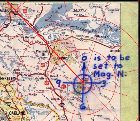
Just out of interest, @DMW, I see from your write up that you interpreted the candidate of 3 3/8 inches along the 10th “radian” as pointing somewhere in the general direction of where Allen’s house would be. Can you remember where exactly on the Phillips 66 map the point fell to your reckoning? I’m just playing around with some tests as to just how much this map may differ in certain areas from what you get after conversion to geophysical coordinates. I have it just about crossing the top of the map over Vallejo, somewhere between maybe Sonoma Boulevard to the west and the I80 to the east. Is that kind of where you pictured it?
“This isn’t right! It’s not even wrong!”—Wolfgang Pauli (1900–1958)
Three and three eighths inches at the 10 o’ clock vector from Mt. Diablo with the provided map scale doesn’t land on Arthur Leigh Allan’s house. It lands south of Lake Herman Road, just as Oliv92 found. The code proves my result and is fully auditable.
My projection is from the Mt. Diablo summit, adjusted for 1970’s magnetic declination of the local region.
There is a 100 foot equilateral triangle landmark that points north and corresponds to the triangle symbol used in the ciphertext on the ground next to the decoded coordinates, and I tested 6 million alternatives.
I think DMW has abandoned the thread, as he dismissed the relevance of the landmark and didn’t answer when I asked him if it was natural in origin.
Oliv92 had the more rigorous methodology to arrive at this plaintext, but was still missing the ranking step. That was because his efforts were not engaged with by others, unfortunately.
I was specifically asking @DMW as I am currently interested just in where the point lies on the map we were given, as located using only a compass and an inch rule, hence the figure. I guess I’m just wanting to check that I’m not using an image of the Phillips that may have been skewed on resizing at some point.
“This isn’t right! It’s not even wrong!”—Wolfgang Pauli (1900–1958)
Well, maybe he will get back to you, but my impression was he ditched the conversation when asked his thoughts/explanation on the origin of the triangle landmark. We’ve heard cow watering hole, but I’m not buying that one.
shaqmeister – I show the spot in Figure 7 and Figure 8 in my write-up. It’s pretty much where you indicate. I’ll point out that there may be a bit of inaccuracy in trying to place the precise spot on the Phillips map. The map contains a pretty limited number of landmarks to work from. Zodiac probably had the same difficulty, though.
coder1987 – I never said that the code led to ALA’s house, only that it COULD be meant to lead there. So many assumptions went into the analysis that it is impossible to say anything categorically.
Also coder1987 – 2 observations. First, your triangle is visible from the air. Where would the Zodiac have seen this image in 1970? (I’m not asking this as a refutation, I’m genuinely curious.) Second, the first triangle in the cypher and the second triangle in the cypher look significantly different. If Zodiac was trying to copy an actual physical landmark, wouldn’t he have tried harder to make them look the same? To be clear – I believe it to be completely possible that Zodiac was pointing to the triangle you are interested in. I just don’t think the evidence is compelling enough to say that this MUST be what he was pointing at. Indeed, I think it’s equally possible that the cypher is just a gibberish string of symbols and doesn’t really point to anything at all.
Hi @DMW, glad to see you have returned, as I thought you had left us.
“Where would the Zodiac have seen this image in 1970?”
I am a bit confused by this question.
“Second, the first triangle in the cypher and the second triangle in the cypher look significantly different.”
This doesn’t debunk the paper or the code.
“If Zodiac was trying to copy an actual physical landmark, wouldn’t he have tried harder to make them look the same?”
This landmark can be made with a shovel. He made the landmark next to Lake Herman Road, the same road as his first crime scene. From the 609ft hill next to this triangle landmark, where the Somerset Tanks currently sit nearby, he can see the Blue Rock Springs attack site.
This is essentially his territory that has been physically marked. Do note that the first triangle symbol is the one overlaid, the others are also a close match, but the first is the closest. There is no rotation or skew applied in the overlay, it is an aspect ratio locked zoom.
Ah meant to add:
Zodiac’s first encrypted symbol was a hollow triangle, in his first cipher.
In his last cipher, his last encrypted symbol is a hollow triangle, which is what you find on the ground when you solve Z32.
Ta-da.
Time to bring in the ground penetrating radar. Fast and cheap.
shaqmeister – I show the spot in Figure 7 and Figure 8 in my write-up. It’s pretty much where you indicate. I’ll point out that there may be a bit of inaccuracy in trying to place the precise spot on the Phillips map. The map contains a pretty limited number of landmarks to work from. Zodiac probably had the same difficulty, though.
Thanks for that, @DMW. I should have thought to just look at your write-up in the first place, but it was kind of late for me when I was thinking about it.
So this is only one example, but what it shows – and what I would have expected from previous experiments – is that the Phillips 66 map is very poorly aligned to the physical terrain. Using just the map and a ruler, we get a location that is in Vallejo to the West of the I80. However, anachronistic application of conversion to physical coordinates straight from the plaintext (ignoring the map completely) gives a location on the other side of the I80, slightly further south. The key takeaway here, then – irrespective of any consideration as to what may be being indicated in either case – is that there are clear discrepencies in even locating the broad area our attention is drawn too based on whether:
- we simply follow the instructions given and apply an inch ruler to the map; or
- we ignore that we were asked to solve puzzle in 1970 and interpolate a method of conversion to actual (precise) geophysical coordinates to derive where we would have located the point were the map an accurately scaled one.
A quick estimate in comparison of the two results for just the one example puts the I80 between the two indicated areas with an intervening distance of about 5 – 6 km.
“This isn’t right! It’s not even wrong!”—Wolfgang Pauli (1900–1958)
Time to bring in the ground penetrating radar. Fast and cheap.
There are also other, even cheaper, routes to follow if you wanted to put in the effort.
Were this feature on this private land to have been constructed in any way by some outside party, we could expect that a scan of the local newspapers of the time would bring up articles titled something like “Strange form appears on farmer’s land. Landowner, scratching head, thinks aliens.” As a matter of public record, the actual landowner of the time could be easily identified and, if considered worth pursuing, the story as to this bizarre appearance could be sought through their offspring to the present day. You would also be able to ask why it was, having first appeared, it wasn’t ultimately cleared away again restoring the land thus abused. You could also simply contact the current land owner and ask what the feature is, and why the cattle trails hug its edges on all sides as if they are drawn to it somehow.
If it wasn’t some outside party that constructed this form, however, then the land owner is The Zodiac and we get, from our pipe dream, even more than we expected!
“This isn’t right! It’s not even wrong!”—Wolfgang Pauli (1900–1958)
shaqmeister – I show the spot in Figure 7 and Figure 8 in my write-up.
Hi @DMW
I’m so glad that you did point me back to your actual write-up, as it prompted me to re-visit the entirety of the presentation of your argument. And I have to say it really is admirably argued. From the detail of your presentation I feel that I have a complete understanding of all the assumptions, even those that are usually left implicit, that you had taken into consideration to build your case. I find also that I don’t have any disagreement with pretty much each of the assumptions that you logically build from.
On another level, just the fact that I was coming back to this after some years made the fact that, since you wrote it, it is now out of date with regard to the solving of the Z340 really stand out. I never thought back then that we would be needing this significant correction after just a few years.
In my own past efforts, the only major additional assumption that I had wanted to factor in was that, in hindsight of the solving of the Z340 along with the Z402, I would be looking for a straightforward readable form foremost. Just as presented in the postscript, I would be favouring something that reads easily and in precisely the order:
Radians &/+ # inches along the radians
In short, I would additionally prioritise any candidates from a wider set that maintained the following characteristics:
- angle (radius) specification before distance specification;
- values before unit specification
- values and units in full, “INCHES” rather than “IN”
- possible inclusion of the ambiguous “&/+” as either “AND” OR “PLUS” in the result
And of course, more than anything else:
The Map coupled with the cipher [solely!] will tell you where the bomb is set.
We’re told precisely what to do. Absolutely no intermediary number conversions need apply.
“This isn’t right! It’s not even wrong!”—Wolfgang Pauli (1900–1958)
@shaqmeister – I think I agree with everything you’re saying, with one possible exception.
Your point #3 – “values and units in full, “INCHES” rather than “IN””.
Take a look at the postscript to the July 26, 1970 letter. There is a big gap between the “in” and the “ches” in the word “inches”. It’s possible the Zodiac originally just wrote “in”, lifted his pen, then decided he wanted to write out the full word. Like he originally used “in” from the cypher, then decided that was too cryptic for the postscript and he ought to write out the full word.
Wild speculation, but I think this at least indicates a possibility that “in” is appropriate.
Also, consider this – what if Z32 is a transposition cypher, like Z340?
Take a look at the postscript to the July 26, 1970 letter. There is a big gap between the “in” and the “ches” in the word “inches”. It’s possible the Zodiac originally just wrote “in”, lifted his pen, then decided he wanted to write out the full word. Like he originally used “in” from the cypher, then decided that was too cryptic for the postscript and he ought to write out the full word.
If there were anything at all that could be read into the spacing, I would not expect it to be intentional. What I could imagine is that he started off writing “Radians + inches along the Radians,” paused after “+ in…” realising that he needed to interpolate “#” to convey his precise intention, did so, then went back to completing the sentence introducing an unintended skip.
Also, consider this – what if Z32 is a transposition cypher, like Z340?
In that event, we would be totally justified in laying down our compass and ruler as there would quite literally be no way to proceed. As has long been acknowledged, the Z32 simply doesn’t get close to the minimal requirements for purely cryptographic methods of solution, even if we limit our attempts to simple homophonic substitution.
“This isn’t right! It’s not even wrong!”—Wolfgang Pauli (1900–1958)
Found this useful map posted on Reddit some years ago:
https://www.arcgis.com/apps/mapviewer/index.html?webmap=cdd970982b764a4fae7e351c8905973f
https://www.reddit.com/r/ZodiacKiller/comments/11pm3a5/mount_diablo_radians_and_inches_online_map/
As we can see, the 10 o’ clock vector hits the south side of Lake Herman Road, as my solver projects.
As we can see, the 10 o’ clock vector hits the south side of Lake Herman Road, as my solver projects.
Sure, I don’t think that anyone would doubt this. Of course, that’s only when you anachronistically use modern mapping solutions, rather than the map you were given. Which highlights the crucial question as to the invalidity of proceeding by the former method.
“This isn’t right! It’s not even wrong!”—Wolfgang Pauli (1900–1958)
