
A question: Can you account for how it is that, without explicit instruction, we are to be expected to use the (erroneous) printed scale on the Phillips 66 but not the (equally erroneous) printed True North?
“This isn’t right! It’s not even wrong!”—Wolfgang Pauli (1900–1958)
Question: on having been given a paper map marked with north and a polar origin, along with a set of coordinates (bearing, range) as an angle and a distance in inches, what is the only rational and unequivocal inference we must make as to what method we are to apply to determine where the coordinates point?
Do we need to know the scale of the map to enable us to carry this task out correctly?
“This isn’t right! It’s not even wrong!”—Wolfgang Pauli (1900–1958)
Question: does the map used even have to be to any accurate scale or properly oriented to carry out this task?
“This isn’t right! It’s not even wrong!”—Wolfgang Pauli (1900–1958)
Question: what is the rationale that would lead us to use the scale of the Phillips 66 to convert a length in inches to a distance in miles when the length in inches is not one which was measured on the Phillips 66?
“This isn’t right! It’s not even wrong!”—Wolfgang Pauli (1900–1958)
Question: given that we are ultimately required, according to your proposed method, to convert a distance, deduced into miles, to a length in inches on some arbitrary map of our choosing, why is the encoded distance (range) not in miles?
“This isn’t right! It’s not even wrong!”—Wolfgang Pauli (1900–1958)

I’ll try to keep this short and answer only the questions asked. Sorry I got carried away with those long posts. I’ll keep my replies as brief as possible from now on.
1. Zodiac instructed us to set zero to magnetic north. A compass allows us to establish magnetic north independently of P66’s orientation error. It does not correct the map’s scale error.
But approximately 6.4 miles per inch is the scale Zodiac gave us through P66. My hypothesis is that this was the specific scale he needed.
Unless he actually checked the distances on P66 against real geography, he may not have known about the scale error. Or perhaps it simply didn’t matter, because 6.4 miles per inch was exactly the conversion he was looking for.
2. The natural approach is to plot the bearing and inches directly on P66, assuming the map is correctly oriented. I agree.
A magnetic compass allows us to establish magnetic north independently of the map’s orientation error, as Zodiac instructed.
The scale is not needed to measure inches on paper. However, P66’s printed scale still states that one inch represents 6.4 miles, whether physically measured or not.
3. No. The map does not have to be geographically accurate to plot the bearing and inches.
P66 explicitly states that 1 inch represents 6.4 miles. That remains the stated conversion factor, regardless of inaccuracies in the physical map.
4. Because Zodiac explicitly coupled the code with P66.
The code gives us the inches, and P66 provides the conversion: 1 inch represents approximately 6.4 miles.
We can plot those inches physically on P66, but the printed conversion factor remains the same whether we measure them on the paper or not.
5. P66 states that 1 inch represents approximately 6.4 miles. Zodiac gives us inches, we plot those inches on P66, and the printed scale tells us the corresponding geographical distance in miles.
We don’t have to convert that distance back into inches on another map. That’s entirely optional, depending on what we want to achieve. We only need to use the distance in miles if we choose to transfer it to another map with a different scale.
Converting it to another map later is just standard map work, not a requirement of the cipher itself.
A question: Can you account for how it is that, without explicit instruction, we are to be expected to use the (erroneous) printed scale on the Phillips 66 but not the (equally erroneous) printed True North?
1. Zodiac instructed us to set zero to magnetic north. A compass allows us to establish magnetic north independently of P66’s orientation error. It does not correct the map’s scale error.
But approximately 6.4 miles per inch is the scale Zodiac gave us through P66. My hypothesis is that this was the specific scale he needed.
Unless he actually checked the distances on P66 against real geography, he may not have known about the scale error. Or perhaps it simply didn’t matter, because 6.4 miles per inch was exactly the conversion he was looking for.
The important question that I am wanting to ask here is not about what The Zodiac did, but about what we can fairly be expected to do, now we have the map and the bearing. The question is crucial because we must assume that the Zodiac’s expectations as to what we would do would guide how much explicit instruction he has to give so that we don’t go wrong and do something else. And he doesn’t give any.
The map has a printed True North on it, as maps generally do. We need to shift the bearing baseline round to magnetic north, so the printed north is precisely what we need. We can be expected to make use of it. The rest follows naturally without further instruction and without any need to convert or calculate anything.
The printed scale only has use if we are performing some conversion calculation of some sort. Nothing in the problem as stated indicates that we need to convert anything—we have been given a length in inches and that is precisely what we need here—we can therefore be expected to give no consideration whatsoever to what the scale says.
Which, in your view, constitutes a plausible expectation of LE’s focus and actions on receiving the map and code? Make the natural shift of the given True North on the map to Magnetic North and just continue, or start performing scale conversions that are nowhere indicated and are not serving any purpose?
“This isn’t right! It’s not even wrong!”—Wolfgang Pauli (1900–1958)
Question: on having been given a paper map marked with north and a polar origin, along with a set of coordinates (bearing, range) as an angle and a distance in inches, what is the only rational and unequivocal inference we must make as to what method we are to apply to determine where the coordinates point?
Do we need to know the scale of the map to enable us to carry this task out correctly?
2. The natural approach is to plot the bearing and inches directly on P66, assuming the map is correctly oriented. I agree.
A magnetic compass allows us to establish magnetic north independently of the map’s orientation error, as Zodiac instructed.
The scale is not needed to measure inches on paper. However, P66’s printed scale still states that one inch represents 6.4 miles, whether physically measured or not.
The natural approach is to plot the bearing and inches on the P66, whether or not the map is correctly oriented. This is, perhaps, your biggest sticking point.
The map we were given could just as well have been one crudely copied in crayon by The Zodiac’s six-year-old daughter and it wouldn’t change a thing. The task is just to point to somewhere on the map that we can identify.
“This isn’t right! It’s not even wrong!”—Wolfgang Pauli (1900–1958)
Question: does the map used even have to be to any accurate scale or properly oriented to carry out this task?
3. No. The map does not have to be geographically accurate to plot the bearing and inches.
P66 explicitly states that 1 inch represents 6.4 miles. That remains the stated conversion factor, regardless of inaccuracies in the physical map.
Plotting the bearing and inches on the map does not require us to give any consideration to the scale of the map in any way whatsoever, whether the printed scale or its actual scale. We are not converting anything. Please try to hold this fact in the forefront of your mind as we continue. As I have stated several times, we can totally forget about anything to do with scale. We are just plotting.
“This isn’t right! It’s not even wrong!”—Wolfgang Pauli (1900–1958)
Question: what is the rationale that would lead us to use the scale of the Phillips 66 to convert a length in inches to a distance in miles when the length in inches is not one which was measured on the Phillips 66?
4. Because Zodiac explicitly coupled the code with P66.
The code gives us the inches, and P66 provides the conversion: 1 inch represents approximately 6.4 miles.
We can plot those inches physically on P66, but the printed conversion factor remains the same whether we measure them on the paper or not.
The question is more subtle than this. If the length in inches was derived from conversion from some other map and, as we have understood, is not the same as the length that we would measure on the Phillips, then why are we using the scale of the Phillips to do the conversion?
“This isn’t right! It’s not even wrong!”—Wolfgang Pauli (1900–1958)
For this last point, think of it like this. Why are we performing a conversion from US Dollars to Euros when the currency we have in our hand is in Yen?
“This isn’t right! It’s not even wrong!”—Wolfgang Pauli (1900–1958)
1. Finding an identifiable point on P66 is easy.
But after 56 years, can you show me just one identifiable point on P66 and explain why Z32 points to that particular location rather than any other?
Just one.
2. If neither the scale nor the orientation of the map matters, how does that work when we have to plot distances in inches?
Wouldn’t six inches on two differently scaled copies of P66 lead to two different locations, especially when you already know that P66 has both an orientation error and an inaccurate geographical scale?
How do you then establish which location is correct in the real world?
Enlighten me please.
3.Which map am I getting my inches from?
The six inches I use come from P66. In fact, I used the only—and the best—P66 map I could find with one-inch intervals marked across the entire map—yours, the one you posted back in March.
According to that P66 map’s printed scale, six inches represent approximately 38.4 miles, whether physically measured on the map or simply calculated.
And since you created that map yourself, I have a question: what method did you use to plot the physical one-inch intervals on the map?
So which other map are my inches supposedly coming from? I really want to know.
And please don’t bring up some imaginary map. Are you suggesting that your own measurements on that P66 map are wrong?
2. If neither the scale nor the orientation of the map matters, how does that work when we have to plot distances in inches?
Wouldn’t six inches on two differently scaled copies of P66 lead to two different locations, especially when you already know that P66 has both an orientation error and an inaccurate geographical scale?
How do you then establish which location is correct in the real world?
Enlighten me please.
Oh my.
You still haven’t got it yet that the only thing we are asked to do with this whole problem is to point to a place on a map that we can name. It doesn’t even matter that it is a map. We could have a list of names just written on a piece of paper, set up some or other coordinate system on the sheet—absolutely any system we like, the choice is irrelevant. The Zodiac happened to have used the same system as you would expect on a map, but he could just have well have given us a Cartesian x, y pair of coordinates—and then give the coordinates that will pick out one name from all the others. And if that name is ‘Concord’, we go to Concord to look for the bomb. We know the correct location in the real world by no other means than that, on the map, our arrow points at ‘Concord’, either its name or some other identifying feature.
Of course, two differently scaled maps would require two different coordinate pairs to point to the same place. But we were only given the one map. A Phillips 66. The very Phillips 66 on which the author had measured the angle and inch distance. We use this map.
I am no longer even able to guess what it is you are unable to understand about this.
“This isn’t right! It’s not even wrong!”—Wolfgang Pauli (1900–1958)
1. Finding an identifiable point on P66 is easy.
But after 56 years, can you show me just one identifiable point on P66 and explain why Z32 points to that particular location rather than any other?
Just one.
I can show you lots of candidate examples and show you precisely where they plot on the Phillips 66. We are all unable however, and forever will be, to say that any one such candidate is the intended location. But that is not a failure of the method. The method is clear. The cipher, however, does not evaluate to a unicity distance sufficient to permit solving.
On the other hand, we can also produce candidates that can be immediately discounted, for no other reason than that they do not apply a reasonable and deducible logic.
Sad to say, yours is one of these.
“This isn’t right! It’s not even wrong!”—Wolfgang Pauli (1900–1958)
3.Which map am I getting my inches from?
The six inches I use come from P66. In fact, I used the only—and the best—P66 map I could find with one-inch intervals marked across the entire map—yours, the one you posted back in March.
According to that P66 map’s printed scale, six inches represent approximately 38.4 miles, whether physically measured on the map or simply calculated.
And since you created that map yourself, I have a question: what method did you use to plot the physical one-inch intervals on the map?
So which other map are my inches supposedly coming from? I really want to know.
And please don’t bring up some imaginary map. Are you suggesting that your own measurements on that P66 map are wrong?
I can’t recall what I may have posted back in March. I did, however, post this in September of this year, on this very thread.

The distance along the radials between consecutive arcs is 1 inch, measured directly from the inch ruler that was placed under the map image this was cropped from.
You’ll see the location of “sixsix” right at the bottom, just to right of centre, below the word ‘Cupertino’ and just slightly south of Steven’s Creek Reservoir (shown on the Phillips) and east of Steven’s Canyon Road.
Here it is transferred to Google Maps along with its direct distance from the approximate summit of Mt. Diablo.
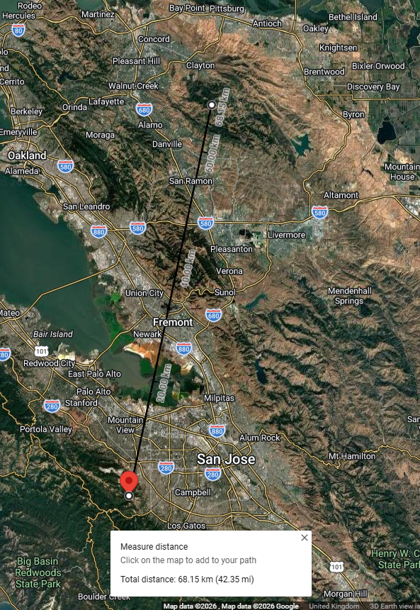
I read this distance as 42.35 miles.
“This isn’t right! It’s not even wrong!”—Wolfgang Pauli (1900–1958)